|
Spatial Projects SQL (spatialSQL)
for MapInfo Professional®
Advanced spatial query and update
 Applications of the Median Line update operator
The
median update operator in conjunction with:
-
 intersects
or intersects
or  disjoint query, disjoint query,
-
 Where Clause,
-
 proximity qualifier
 -
 within distance
tolerance within distance
tolerance
provides a method of creating median lines or polygons. A median
line is the line which is equidistant at all points from the nearest point on
the objects from which it was created.
There are many applications for median lines including:
-
Creating street centrelines from cadastral boundaries;
-
Creating median maritime boundaries between countries;
-
Trim catchment areas to the median line version;
-
Creating median lines between selected point, line or region
objects.
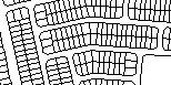  |
Street Centreline Example
The combine operator is used to create casements from
cadastral data
|
 |
Centrelines are then created automatically from the casements and a
nominated search width. |

 |
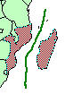
Catchment Area Example
Median Update supports a range of applications including the
clipping of catchment areas.
|
|

|
Maritime boundary generation.
There are a number of important provisos detailed in the
documentation but a good approximation to economic and territorial boundaries
can be produced.
|
|
 
|
Arbitrary Selected Objects
Create median lines between any selected objects
|
|


The median boundary between polygons is derived from the buffered boundary. The
edge match between the new boundaries will be exact but the generated boundary
nodes will not be recreated at the same location as the original polygon.
Attributes attached to the buffered polygons are preserved in the median update
version.
See a movie of the operation
|
Buffer - Preserving Original Polygon Boundaries
Input polygons with some boundaries touching.
MI Pro:Uniform buffer of each object.
spatialSQL:
 set table 1 set table 1
query
zero buffer
update
 run the update run the update
|
|

 Home
Home Product Map
 Links
Links Free Tools
 LayMan
 Introduction
 Highlights
 Solutions
 Features & Benefits
 What's New
 Download
 Purchase
 spatialSQL
 References
 Object Properties/
 Median Lines
 Region Centroids
 Region Smart
 Parallel Arc
 Documentation
 spCarto
 PolyLabel
 MBTestBench